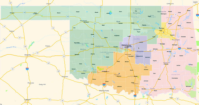
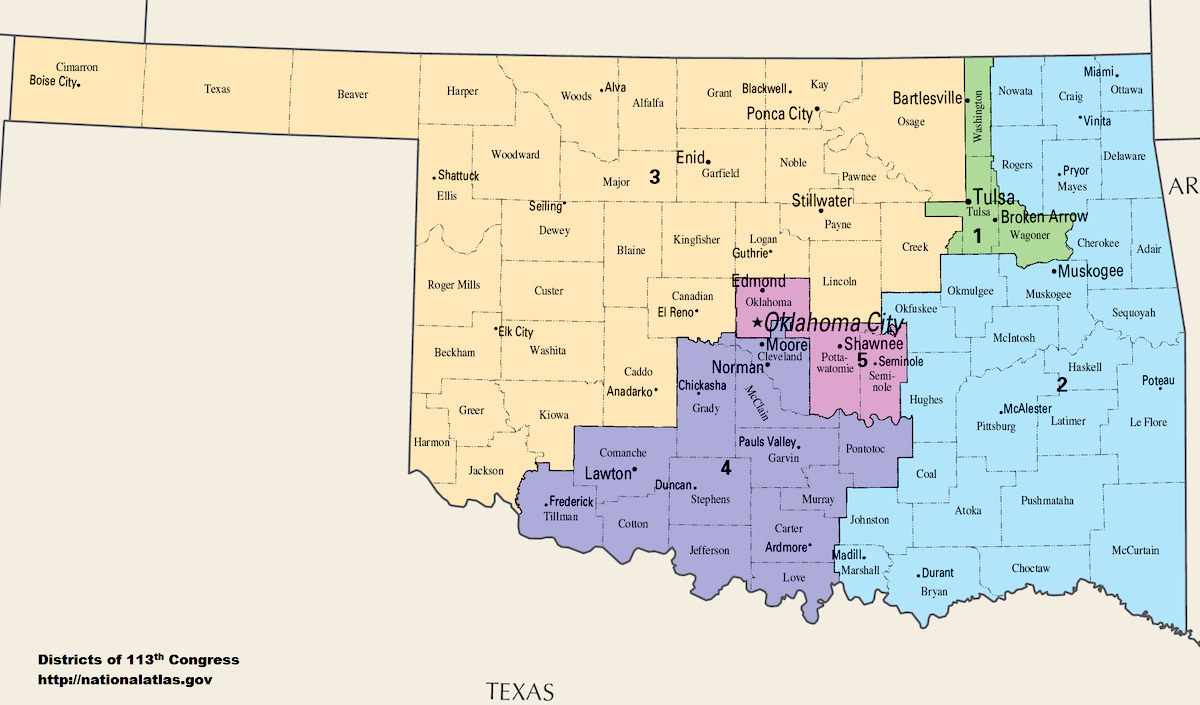
Republican state lawmakers unveiled their new proposed Oklahoma congressional map today, which will shift 180,762 residents of central and southwest Oklahoma City from the state’s 5th Congressional District to its 3rd Congressional District. At the same time, 44,896 residents of Logan County (including the city of Guthrie) and 33,458 people from the largely rural Lincoln County will now be in CD 5.
Additionally, 84,282 residents of Yukon, Piedmont and other municipalities in Canadian County will also join CD 5, which had been the state’s most competitive congressional district. (Democrat Kendra Horn defeated incumbent Republican Steve Russell in 2018 and then lost to Republican Stephanie Bice in 2020 by about 13,000 votes.)
The Legislature is set to convene for a special session Monday, Nov. 15, explicitly to address the state’s redistricting requirements, which were delayed by the late arrival of official 2020 U.S. Census Bureau data. The fastest lawmakers could approve maps would be five days.
“Right now, Oklahoma City is already represented by three members of Congress. It’s just where that line is drawn,” said Sen. Lonnie Paxton (R-Tuttle), the Oklahoma State Senate redistricting chairman. “The fact that Oklahoma City has three representatives in Congress has not changed. For example, some of the areas in the Lincoln and Logan County areas, some input we had from some of the agriculture groups is that they would like to have some type of influence and rural influence in every congressional district. There was discussion on that. All of that stuff kind of came into play.”
PROPOSED MAPS
When it comes to congressional redistricting, considering “all of that stuff” is a balancing act between concepts such as population equality, keeping counties whole, district compactness and continuity of community representation. Paxton and his House counterpart, Rep. Ryan Martinez (R-Edmond), said the new proposed Oklahoma congressional map splits up six counties — an increase of two compared to the existing map — and said the 5th Congressional District map has a higher “compactness score,” a concept with competing methodologies but which generally rewards more circular districts and penalizes narrow “land bridges” between major communities.
“If you look at Congressional District 5 as presented here, it’s much more compact. It’s much easier to kind of understand the connection than it was before,” Martinez said. “So we achieved that goal. So, theoretically, you could draw the lines elsewhere and be at the expense of compactness.”
But Martinez’s explanation and the mathematical calculations of circular compactness are unlikely to sit well with residents of Oklahoma City whose congressional representation will now be shared with residents of western Oklahoma in towns such as Weatherford, Elk City, Woodward and Guymon, which is about 260 miles away.
“I’m mad as hell about it,” said Rep. Forrest Bennett (D-OKC), whose legislative district spans central and southern Oklahoma City. “These new (congressional) district lines split my (state House) district exactly where city leaders and community activists have been trying to build bridges.”
OKC Democrats: ‘The powers that be have chopped this city up’
Bennett said the new proposed Oklahoma congressional map will further separate “northside” and “southside” OKC residents.
“The message that this map sends is going to be pretty clear to the folks south of it, regardless of official explanations,” Bennett said. “At a time when just about everybody involved in OKC’s business and political spheres have worked toward that ‘1OKC’ ideal, the powers that be have chopped this city up in a way that’ll be more painful for communities of color than it will be for the rest of us.”
Rep. Jose Cruz (D-OKC) concurred with Bennett’s assessment.
“At the state of the city address (today), Mayor David Holt mentioned that 60 percent of our children in Oklahoma City are non-white,” Cruz said. “The GOP is doing everything in their power to protect themselves instead of representing their constituents. This sends the century-old message to south Oklahoma City that we don’t matter. It’s disgusting and unconstitutional.”
Martinez, the most powerful Hispanic member of the Oklahoma Legislature, said he is “absolutely” confident that the new proposed Oklahoma congressional map would withstand any legal challenge.
During his press conference, Martinez was asked about the potential impact of shifting the substantial Latinx population of southwest OKC into a separate congressional district from the rest of the city.
“We don’t take race into account,” Martinez said, referencing federal redistricting rules. “It’s pretty clear there is not a minority-majority district in Congress in Oklahoma. (…) I don’t think somebody moving from CD 5 to CD 3, I don’t think they’re going to get a lesser voice in Congress.”
Asked if he or Paxton received any formal communication or input from Hispanic leaders or groups in Oklahoma City, Martinez said, “I don’t remember specifically. There’s not an organization I think I can remember.”
At the start of the Martinez and Paxton press conference, legislative staff distributed six letters supporting elements of how the new proposed Oklahoma congressional map affects central Oklahoma. The Greater Oklahoma City Chamber of Commerce wrote, “we believe this substantial population shift into central Oklahoma warrants increased representation in Congress for our region.”
An economic development group called Shawnee Forward requested to have Pottawatomie County remain in CD 5 because it is “integrally connected” with Oklahoma County. The vice chairwoman of the Citizen Potawatomi Nation also asked for her sovereign tribal nation’s local constituents to remain in CD 5. A Guthrie City Council member asked that his community be added to CD 5 because Guthrie has an “intrinsic relationship” with Edmond and Oklahoma City.
“I do represent northwest Oklahoma County where Edmond touches Guthrie. It’s very clear that Guthrie and Edmond are very intertwined,” Martinez said, noting that the cities share an airport. “Guthrie has become more of a suburb of Oklahoma City. There is a benefit of having Guthrie and Edmond in the same congressional district.”
Meanwhile, the mayor of Midwest City asked that his community and Tinker Air Force base remain in CD 4, which would be adjusted in the new map to include 85 percent of Midwest City and the entirety of Del City, Martinez said. The Oklahoma Farm Bureau’s president also wrote a letter stating that, for 79 years, the Farm Bureau’s “members have expressed a clear preference for all five congressional districts to include a portion of both rural and urban areas.”
But Bennett criticized the proposed new CD 5 boundary as likely to hurt residents of south OKC.
“Some folks say that having multiple members of Congress responsible for parts of OKC gives the city a bigger presence in Washington. But, back home, the needs of inner city southsiders — needs not terribly unlike those who live downtown or in inner city east side — will compete with the needs of the panhandle and vast swaths of western and northern Oklahoma,” Bennett said. “I see a clear purpose in these lines: dividing and diluting the diverse voices of central Oklahoma. It’ll take a lot of convincing to get me to see a different one.”
Martinez pushed back against any notion that moving some of central and most of southwest OKC into a new congressional district poses a problem.
“Assuming that that was the only criteria and the only district you were looking at, it would be very easy to make those assumptions. But looking at this holistically and looking at a long list of criteria, this seemed to make the most sense. So are there a million different ways you could draw this? Absolutely. But what we had to look at is what benefits the most and all Oklahomans to make the puzzle fit together,” Martinez said. “There are a lot of moving parts here, more than just one thing like, ‘Hey, this community might live closer to this one.’ That’s one factor, absolutely. But there are also a lot of other factors that go into this map.”
Legislative districts will be adjusted as well
State lawmakers will also consider modifications to their new House and Senate districts, which had originally been approved in May using the U.S. Census Bureau’s 2015-2019 American Community Survey data because the official 2020 census data was delayed owing to the pandemic.
State legislative districts are allowed to have a 2.5 percent plus-or-minus deviation in population, while congressional districts are required to be divided equally down to individual persons.
“When the actual data came out in mid-August and the detailed data came out in September (…) we noticed that in several parts of the state the suburban areas grew more than with the estimates,” Paxton said. “A lot of our districts shifted more to the population centers (of the Oklahoma City and Tulsa metro areas)”
A former mayor of Tuttle, Paxton said his Senate District 23 will shift from a suburban-rural mix to a largely suburban population.
“All incumbents are still in their districts,” Martinez said, saying he believes voters should determine whether to remove a legislator from office, “not people drawing maps.”
With adjustments being finalized for legislative and congressional districts in November 2021, Martinez said legislators will run a bill in special session to adjust the residency requirement timeline ahead of the April filing period for the 2022 election.
“That will be addressed. It will be moved back for legislative and congressional seats,” Martinez said. There will be plenty of time to move or adjust or figure out where you are. We will make sure people have plenty of time.”
Martinez said a “late December deadline” for candidates to establish residence and registration could be on the table.
“[These are] intended to be the maps that we take to special session,” Paxton said. “The public input period has been going on for months.”
Martinez, however, noted that citizen input could be ongoing.
“Since these maps are going through a normal legislative process, it’s amazing how representative government works,” he said. “If someone’s constituents are calling them off the hook and saying, ‘This is a terrible map and it doesn’t work,’ well, I’m guessing that their senator and representative don’t want to support that kind of map.”
The proposed Oklahoma congressional map can be found here, with the revised proposal for Oklahoma State Senate districts here and Oklahoma House districts here.


